

Storm Team 4 is monitoring a weekend of wet weather for the Badger State. Rounds of showers/storms are in the forecast starting tonight through Tuesday. While not every day will be a washout, there is considerable uncertainty about exactly where and when the heaviest rain will fall.
The first round may begin late tonight as showers/storms form in central Wisconsin. Some high-resolution models have suggested storms may break off this corridor and head towards SE Wisconsin first thing Saturday morning. Heavy rain is the primary concern given the recent flooding in the area. There is also a chance that storms may remain farther North and leave southern Wisconsin mainly dry.
Regardless, Saturday looks steamy. A lack of rain will allow temperatures to soar into the upper 80s and lower 90s. Dew Points may hover in the lower 70s. Any rain will keep our highs in the low 80s.
Watch: When storms are expected
A big part of the uncertainty is how each round of rain will impact the next. Any residual outflow boundaries (mini-cold fronts from the storms) will be the focus of development the next day.
After a dry stretch Saturday afternoon, additional showers/storms are possible late Saturday and into Sunday. Again, what happens overnight will impact what happens during the afternoon on Sunday.
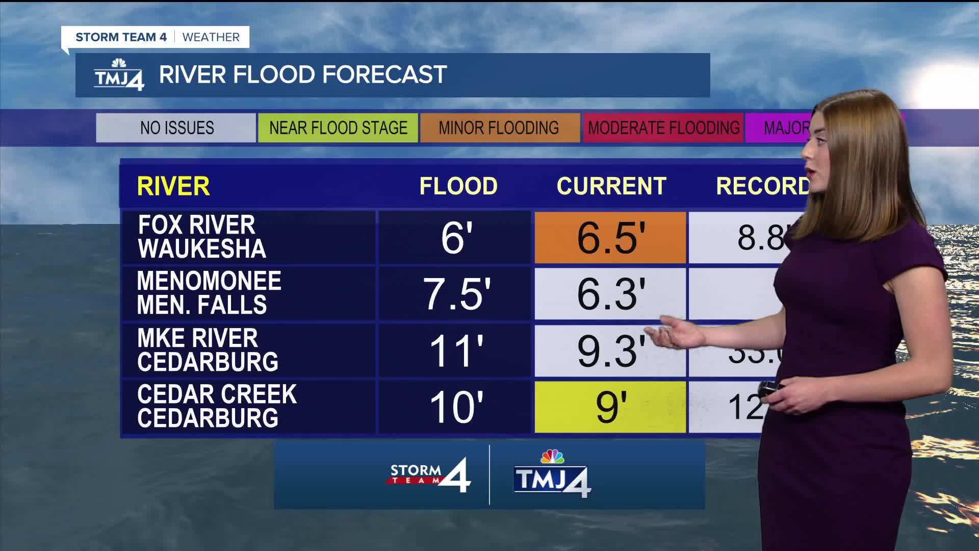
Given the high dew points and available moisture, there is a concern that flooding could quickly return to areas which were soaked last weekend. Stay up-to-date with the forecast throughout the weekend!
Rain chances continue into Monday & Tuesday before drier weather takes hold mid-week. Highs are expected to cool into the 70s.
FRIDAY: Mostly Sunny & Warm
High: 85
Wind: S 5-10
TONIGHT: Chance Showers/Storms; Partly Cloudy
Low: 72
Wind: SW 3-5 mph
SATURDAY: Partly Cloudy, Very Warm, and Humid; Chance Rain/Storms
High: 88
Wind: W 5-10
SUNDAY: Partly Cloudy, Very Warm, and Humid; Chance Storms
High: 83
MONDAY: Chance Showers/Storms; Partly Sunny
High: 81
TUESDAY: Chance Showers/Storms
High: 78
It’s about time to watch on your time. Stream local news and weather 24/7 by searching for “TMJ4” on your device.
Available for download on Roku, Apple TV, Amazon Fire TV, and more.
