Get ready for an active week of weather! Several rounds of showers and storms bring a chance of flooding and severe weather.
Overnight lows only fell back to around 60-degrees. Clouds are overhead this morning, but will give way to filtered sunshine later this morning & afternoon. Highs climb into the mid-70s. A few spots of patchy drizzle are possible.
WATCH: Southeast Wisconsin weather: Showers and storms
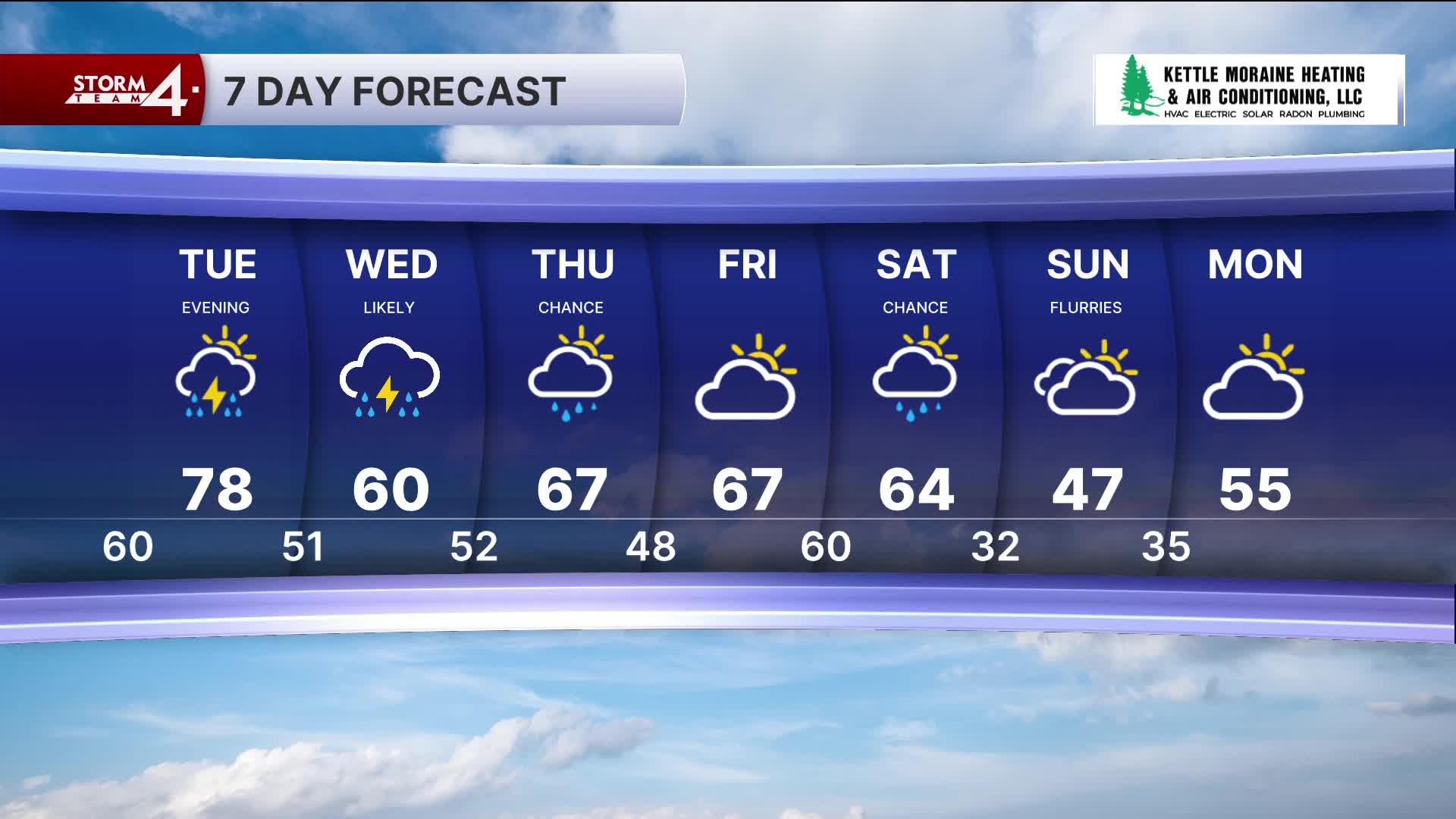
Warm air aloft will serve as a "cap" for any potential storm development this afternoon. If a spotty storm were to erupt this afternoon, gusty winds & hail would be possible. Attention is focused on central Wisconsin late this afternoon & evening. A cluster of strong storms is expected to form in the vicinity of a stalled frontal boundary. While the highest threat of severe weather will occur just to our North, storms will eventually move to the southeast overnight. As the storms lose their strength, areas north of Milwaukee will need to watch out for hail and gusty winds. Storms will exit the area shortly after 5am.
Much like Monday, Tuesday will start off largely dry and stay that way through the early afternoon. The stalled frontal boundary will have shifted farther South — thus increasing the chances of storm development over SE Wisconsin. The Storm Prediction Center (SPC) has posted an Enhanced (Level 3) risk of severe weather across southern Wisconsin. All types of severe will be possible if the front is draped over the Badger State. Storms are expected to fire during the late afternoon or early evening. Storms will move to the southeast before clearing during the early morning hours.
A few showers may linger into Wednesday morning. Once again, storms may fire along a stalled frontal boundary. However, there is uncertainty as to whether the front will remain in southern Wisconsin or drop South into Illinois. Severe chances would be much lower if the front remains to the South. Expect a chance for scattered showers and storms Wednesday afternoon and into the evening hours.
A brief break is expected on Thursday and Friday before another round of rain over the weekend.
Although the severe weather chances are top of mind, these rounds of storms will bring widespread 1-3" rainfall totals across the region. Milwaukee is already 3" above the April month-to-date normal rainfall. Flooding is also a concern through this period — especially along & near area rivers. Stay tuned to Storm Team 4 for the latest.
MONDAY: Partly Cloudy and Warm; Chance PM Storms
High: 74
Wind: SSW 10-15 mph
TONIGHT: Chance Rain & Storms; Mostly Cloudy
Low: 60
Wind: S 5-10 mph
TUESDAY: Partly Cloudy and Warm; Chance PM Storms
High: 75
Wind: SW 5-10 mph
WEDNESDAY: Chance Rain/Thunderstorms
High: 62
THURSDAY: AM Showers; Partly Cloudy
High: 67
FRIDAY: Partly Sunny
High: 70
It’s about time to watch on your time. Stream local news and weather 24/7 by searching for “TMJ4” on your device.
Available for download on Roku, Apple TV, Amazon Fire TV, and more.