


Hurricane Melissa was downgraded to a Category 3 storm Tuesday after making landfall on Jamaica, where it brought fierce winds, feet of storm surge and several feet of rainfall.
On Tuesday evening, Melissa had declined to a Category 3 hurricane with maximum sustained winds of 125mph.
Damage from winds was expected to gradually subside, but the National Hurricane Center warned residents of Jamaica to stay in shelter until Wednesday.
An additional 6 to 12 inches of rain were still expected across Jamaica through Tuesday night. Isolated areas could receive as much as 30 inches. Catastrophic flooding and landslide risk was forecast to continue through Tuesday night.
Storm surge flooding was forecast to subside on Jamaica's southern coast as the night went on. Storm surge totals of 2 to 4 feet were possible on the northern coast of the island.
The storm first made landfall near New Hope, Jamaica, as a Category 5 with top winds of 185 mph — among the most powerful hurricanes ever recorded in the Atlantic basin.
At landfall, Melissa’s central pressure dropped to 892 millibars, making it the most intense hurricane to strike land in the Atlantic since 1935 and tying it for the third-most intense storm ever recorded in the basin.
As devastating as the wind and surge could be, forecasters warned the heaviest damage could come from rain. The National Weather Service said the storm could drop a total of up to 30 inches of rain across much of the island, with higher elevations possibly seeing as much as 40 inches — raising the risk of catastrophic flooding and mudslides.
IN CASE YOU MISSED IT | Researchers say modern, powerful hurricanes need a new category
While the eye missed Kingston to the west, the capital region will still see heavy rain and hurricane-force winds throughout the day.
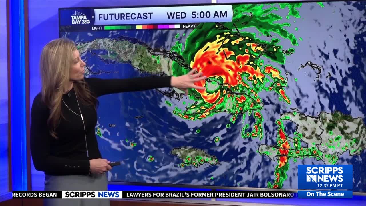
Although Melissa is expected to weaken further as it moves over Jamaica’s mountains, forecasters say it will likely regain strength once it reemerges over open water later Tuesday. The storm could strike eastern Cuba on Wednesday as a major hurricane.
In Cuba, a hurricane warning was in effect Tuesday night for Granma, Santiago de Cuba, Guantanamo, Holguin, and Las Tunas.
Hurricane conditions were expected to arrive in Cuba late on Tuesday and early on Wednesday.
Rainfall totals could reach 10 to 20 inches, with isolated mountainous areas receiving as much as 25 inches. The National Weather Service warned of potentially catastrophic and life-threatening flash flooding and mudslides.
Storm surge along the southern coast of Cuba could reach 8 to 12 feet above normal as the storm approaches.
RELATED STORY | Jamaica warned to shelter in place as Category 5 Hurricane Melissa approaches
Jamaican Prime Minister Andrew Holness said the United States was among the nations that had pledged support.
“We have received calls of support from our partners — the United Nations, United States, the British, the French, the European Union, the Caribbean Disaster Emergency Management Agency (CDEMA),” he said. “All the CARICOM countries have reached out to pledge support in one way, shape or form, and I want to thank all of them for being so willing to support our recovery efforts and our preparation efforts as well.”
He urged residents not to rely on outside assistance for the next three days and to ensure they have enough water to survive.
“Normally with a hurricane, you focus on two things — wind and rain — because it happens very quickly. Now we have to focus on three things: wind, rain and the length of time it will probably linger over the country,” Holness said. “You’re not just dealing with saturation; you’re dealing with a high level of destruction, a higher probability of landslides, a higher probability of flooding even in areas where flooding would not have taken place, so we have to bear that in mind and be prepared.”
A U.S. State Department spokesperson told Scripps News it was cooperating with Jamaica to prepare aid and recovery.
"The State Department has received the formal assistance request from the Government of Jamaica and is working with the government accordingly to assist the people affected by Hurricane Melissa," the spokesperson said. "The State Department maintains warehouses around the world from which we can distribute lifesaving aid in the aftermath of natural disasters. The Department has prepositioned emergency relief supplies in six warehouses that will allow for the distribution of emergency relief supplies to people affected by the storm."
![SNG_Digital_Ad_480x360_CTA[13].jpg](https://ewscripps.brightspotcdn.com/dims4/default/765a37a/2147483647/strip/true/crop/480x360+0+0/resize/960x720!/format/webp/quality/90/?url=http%3A%2F%2Fewscripps-brightspot.s3.amazonaws.com%2F7d%2Fdb%2F0b14063144e881c22c4592637e0d%2Fsng-digital-ad-480x360-cta13.jpg)