
We have a strong storm system that will be affecting us today, tonight and Monday. The main shot of snow will be overnight Sunday into Monday morning that we'll talk more about in a bit.
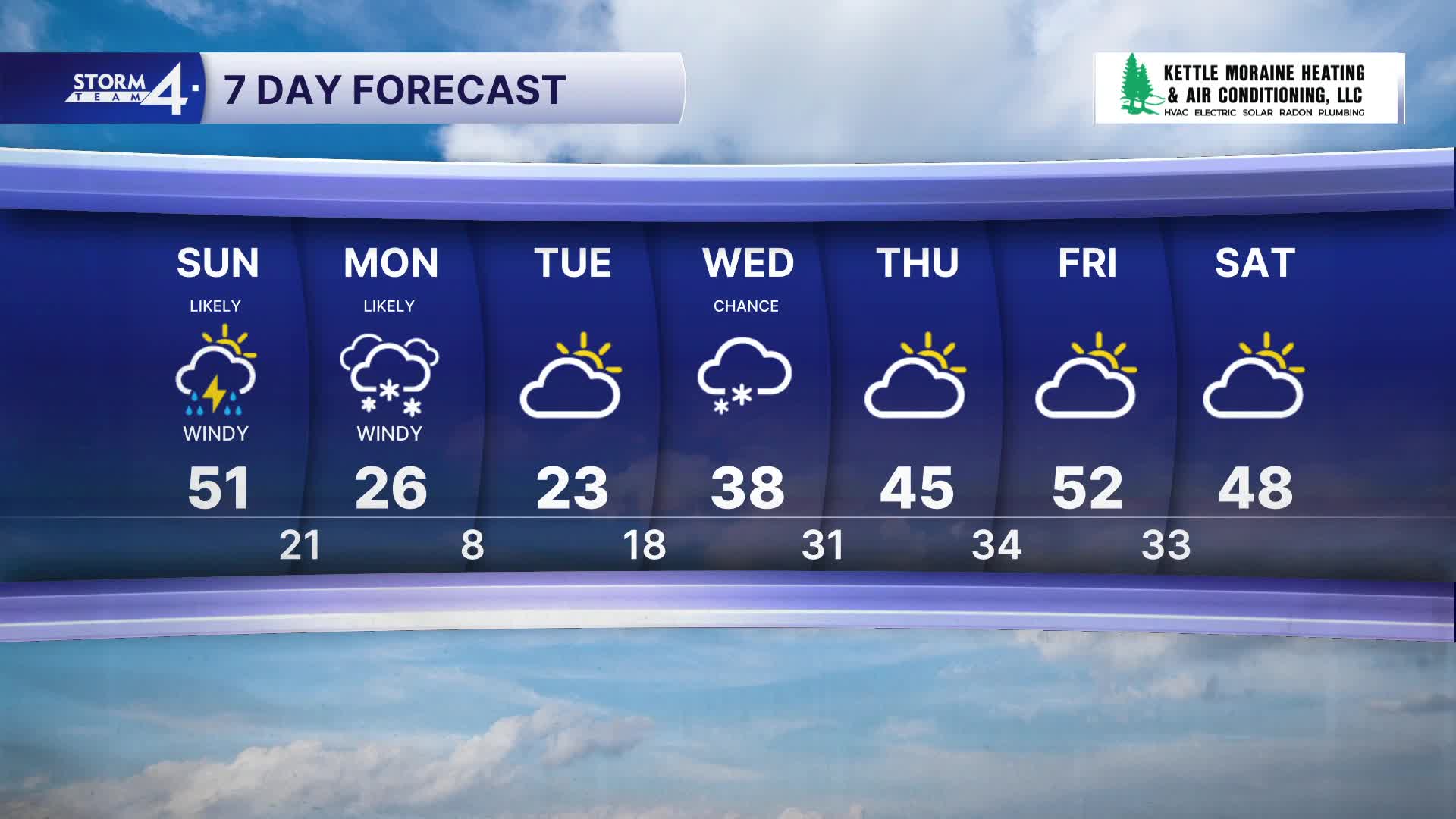
Showers will become more widespread as Sunday wears on. There could even be a few thunderstorms as this rain moves through. It will be windy and mild with highs in the low 50s, though cooler north. Well to the northwest, there could be a little wintry mix at times.
WATCH: What will the strong storm system look like today?
The main snow event gets here late Sunday night with most of the snow overnight Sunday into Monday morning. Monday is going to be snowy and very windy with blowing snow as well. The farther you live to the northwest, the more snow you are going to see out of this. Areas near Milwaukee will end up between 3-5". Racine and Kenosha, only 2-4". Areas northwest of Milwaukee, 6-12" with those highest totals well to the northwest. Wind gusts will top out over 40 MPH out of the NW with highs only in the mid 20s.
Once we get through this, Tuesday will be cold with highs in the low 20s.
We'll be doing plenty of melting by Thursday with highs in the 40s to around 50 into next weekend.
HERE'S YOUR LATEST STORM TEAM WEATHER FORECAST FOR MILWAUKEE
AND SOUTHEASTERN WISCONSIN BY METEOROLOGIST MICHAEL FISH
****WINTER WEATHER ADVISORY FOR SHEBOYGAN, DODGE, AND FOND DU LAC COUNTIES***
UNTIL 4PM THIS AFTERNOON AND 10AM THIS MORNING FOR WASHINGTON AND OZAUKEE COUNTIES.
TODAY: Windy with occasional showers and possibly a t'storm, Some Mix North
High: 51 though cooler north.
Wind: Bec. S 10-20 gusting to 35 mph.
***WINTER WEATHER ADVISORY GOES INTO EFFECT AT 10PM TONIGHT FOR
MILWAUKEE, WAUKESHA, RACINE, KENOSHA AND OZAUKEE COUNTIES***
UNTIL 4PM MONDAY
***WINTER STORM WARNING GOES INTO EFFECT MAINLY THIS EVENING FOR
JEFFERSON, WASHINGTON, SHEBOYGAN, DODGE AND FOND DU LAC COUNTIES***
UNTIL 4PM MONDAY.
TONIGHT: Very windy with rain or a t'storm changing to snow
through the night..2-3" by morning in MKE, more northwest, less southeast.
Los: 21.
Wind: N 15-30 gusting to 40 MPH.
MONDAY: Snow and wind..3-5" total MKE, 6-12" well to the northwest.
High: 26.
Wind: NW 20-30 gusting to 45 MPH.
TUESDAY: Partly Cloudy
High: 23
WEDS: A chance of a few snow showers in the morning.
High: 38.
THURS: Partly cloudy.
High: 45.
It’s about time to watch on your time. Stream local news and weather 24/7 by searching for “TMJ4” on your device.
Available for download on Roku, Apple TV, Amazon Fire TV, and more.
