

A Winter Storm Watch is in effect from 4 p.m. Sunday until 7 p.m. Monday for Racine, Kenosha, Milwaukee, Walworth, Waukesha, Washington, Ozaukee, Sheboygan, Fond du Lac, Dodge, and Jefferson Counties.
A Winter Weather Advisory is in effect from 7 p.m. Saturday until 10 a.m. Sunday for Washington, Ozaukee, Sheboygan, Fond du Lac, and Dodge Counties.
A High Wind Warning is in effect for all of southeast Wisconsin until 4 p.m.
It has been an extremely windy day with widespread power outages throughout southeast Wisconsin. Winds peaked near 60 mph and will slowly go down this evening.
By late tonight, gusts should only reach 30 mph.
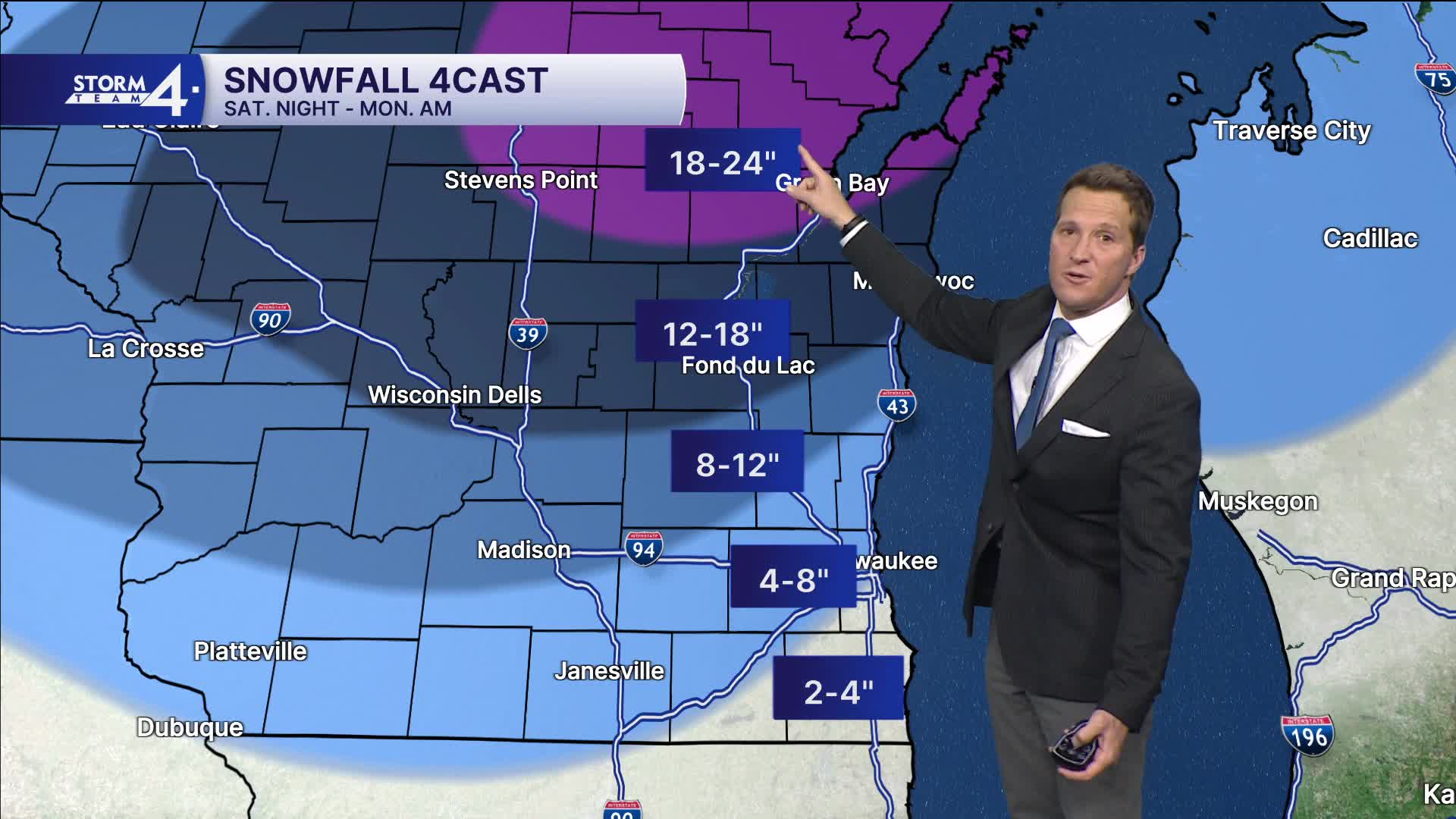
WATCH: How much snow could we actually get this weekend?
Our big winter storm is trending later and north. We still expect an initial round of light snow Saturday evening, especially north of Milwaukee, where 1-3" of snow is possible.
Precipitation then changes to all rain for almost all of SE Wisconsin on Sunday. We'll likely even see a period of dry weather.
Things ramp up Sunday evening, as precipitation fills in and eventually changes over to snow. The worst combination of wind and snow lines up for Monday morning. Snow and wind could continue most of the day. Metro Milwaukee likely ends up with 4-8" of snow, with less south and more north.

TONIGHT: Partly Cloudy and Still Windy
Lows: 28
Wind: NW 15-25 mph
SATURDAY: Partly Cloudy. Ch. Light Snow At Night. 1-3" Possible North
High: 36
SUNDAY: Windy with Showers Likely, Some Mix North
High: 45
MONDAY: Snowy and Windy. 4-6" Total MKE, More Northwest.
High: 26
TUESDAY: Partly Cloudy
High: 23
It’s about time to watch on your time. Stream local news and weather 24/7 by searching for “TMJ4” on your device.
Available for download on Roku, Apple TV, Amazon Fire TV, and more.
