

****Winter Weather Advisory from 12/9/2025 6:00 PM to 12/10/2025 6:00 AM CST for Washington County, WI, Ozaukee County, WI, Sheboygan County, WI, Fond du Lac County, WI, Dodge County, WI.****
After a mild day in Southeast Wisconsin, we have a roller coaster week ahead. You can expect melting, freezing, cloudy skies, sunshine, rain showers, snow showers, and maybe even freezing rain!
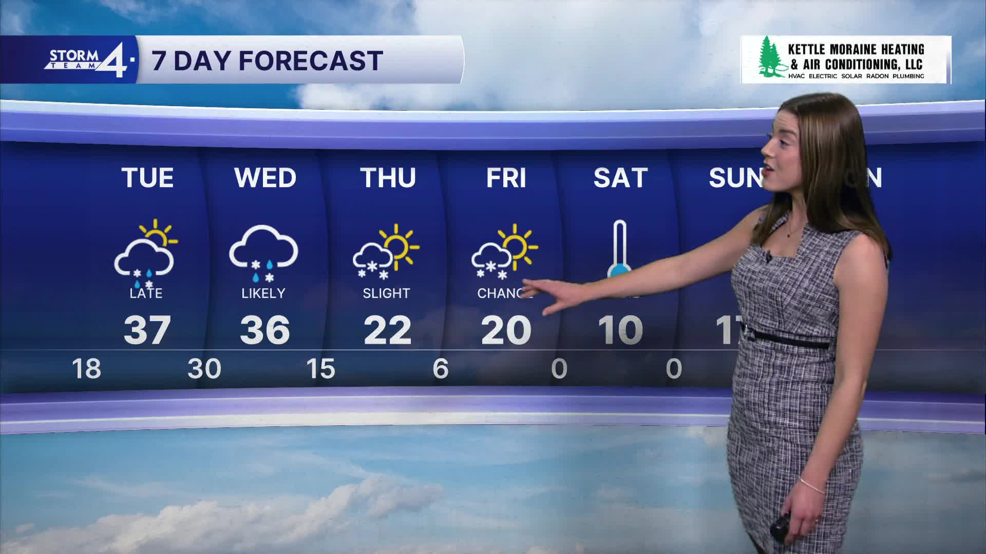
Tonight, our lows fall into the teens as another clipper system rolls through Wisconsin. A dusting to an inch of snow is possible — especially far North of Milwaukee. Slick spots are possible early Tuesday morning.
Watch: Cold & snowy week ahead
A dynamic low-pressure system rolls by late Tuesday and into Wednesday. The track of this system will determine where any snow would fall and who will see rain.
Snow & rain showers begin late Tuesday afternoon and continue overnight. Temperatures warm into the upper 30s by Tuesday. We're closely monitoring where the rain/snow line sets up — which would be the cutoff for any snow totals across the area. As the low pushes East, cold air wraps around into southern Wisconsin late Wednesday. Falling temperatures are expected, along with a transition to all-snow conditions.
Areas near & along I-94 may see up to an inch of snowfall. Farther North, snowfall totals may reach 1-3". Any shifts in the rain/snow line will impact snow totals. Given cold pavement temperatures, there is a chance for rain to create icy conditions on untreated surfaces.
High temperatures are back down to the teens with lows approaching 0 degrees for the weekend.
TONIGHT: Some snow, Cloudy
Low: 18
Wind: S 5-10 mph
TUESDAY: Mostly Cloudy, Rain/Snow Mix Late
High: 38
Wind: W 10-15 mph
WEDNESDAY: Mixed Precip, Temps Falling
High: 36
THURSDAY: Mostly Cloudy
High: 22
FRIDAY: Chance Snow
High: 20
SATURDAY: Sunny and Frigid
High: 10
It’s about time to watch on your time. Stream local news and weather 24/7 by searching for “TMJ4” on your device.
Available for download on Roku, Apple TV, Amazon Fire TV, and more.
