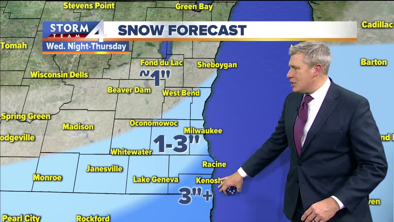


It was partly cloudy, windy and cold today with temps near freezing all day and wind chills in the teens. Clouds increased by late afternoon ahead of the next storm system that is brining heavy snow to Texas and Oklahoma tonight. It rapidly moves toward Wisconsin but we will not see any snow during the daylight hours. Wednesday is cloudy and 30 with a light breeze, and we won’t see our first snowflake until after 9pm. By Thursday morning we will wake up to 1-2” in Milwaukee and less than 1” well north. The snow showers continue in the morning with another 1” in Milwaukee and 1-2” in Racine, Kenosha and Walworth counties. Areas well north of Milwaukee will see about 1”, Milwaukee and Waukesha 2-3”, and areas south will get 3” to maybe 4”. The light snow tapers off in the afternoon with a high temp of 30 and a light breeze. The heavy snow will be in central Illinois. This should also be a light fluffy snow.
Friday and Saturday are mostly cloudy and seasonal with highs near freezing and a light breeze. The next storm will bring snow showers Sunday afternoon with the heaviest snow in central Wisconsin. Monday and Tuesday are quiet with sun and highs in the low 30s.
TONIGHT: Mostly cloudy and frosty
Low: 20 lakefront…13 Inland
Wind: N 5-10 mph
WEDNESDAY: Mostly cloudy with light snow after 8pm
High: 30
Wind: NE 5-10 mph
THURSDAY: Morning snow likely, then cloudy
Accumulation: 2-3” in Milwaukee, 1” north, 3-4” Kenosha
High: 30
Wind: N 10-15 mph
FRIDAY: Mostly cloudy
High: 30
Wind: N 5-10 mph
SATURDAY: Mostly cloudy and seasonal
High: 32
Wind: W 5-10 mph
SUNDAY: Cloudy with afternoon snow
High: 33
