

Happy Thanksgiving!
It is a classic November day in Southeast Wisconsin. We had extra helpings of gusty winds, snow flurries and highs in the 30s. A true harvest of blessings.
It almost feels like true winter. We are only 24 days away from the official start of Astronomical Winter.
As the area of low pressure moves to the east, we will see a gradual clearing sky will allow lows to fall into the teens and lower 20s tonight.
Sunshine breaks out for a bit on Friday with highs in the lower 30s.
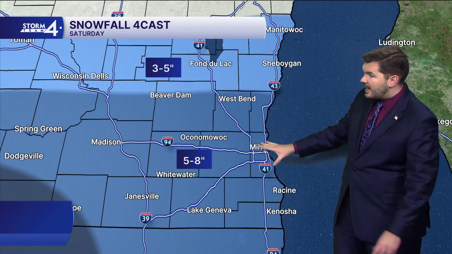
Storm Team 4 is monitoring a Winter Storm that will impact southern Wisconsin throughout Saturday.
An area of low-pressure passes to the South of Wisconsin. Meanwhile, a broad swath of snow will pass over the Great Lakes throughout Saturday. Light to moderate snow showers begin early Saturday morning and continue all day. Snow will taper off from West to East by late Sunday morning.
Watch: Monitoring a weekend winter storm
While some changes are still possible, confidence for a 6"+ snow event has increased.
Most of southern Wisconsin may receive 5-8" of light, fluffy snowfall. Easterly winds off Lake Michigan could lower totals slightly at the lakefront. Snowfall totals will be lower farther North.
The National Weather Service has issued a Winter Storm Watch for all of SE Wisconsin effective 12 a.m. Saturday through 6 a.m. Sunday.
Once the snow tapers off on Sunday, bitter cold sets in for next week.
THURSDAY NIGHT: Slight Chance Flurries; Gradual Clearing
Low: 21
Wind: NW 15-20 G 25 mph
FRIDAY: Mostly Sunny & Cold
High: 30
SATURDAY: Snow Likely; 5-8" Accumulation; Less Lakeside & Far North
High: 34
SUNDAY: Snow Early, then gradually tapering off; Mostly Cloudy
High: 32
MONDAY: Partly Sunny
High: 21
TUESDAY: Partly Cloudy
High: 24
It’s about time to watch on your time. Stream local news and weather 24/7 by searching for “TMJ4” on your device.
Available for download on Roku, Apple TV, Amazon Fire TV, and more.
