

***FROST ADVISORY IN EFFECT MIDNIGHT TO 8A SATURDAY FOR MILWAUKEE, RACINE, AND KENOSHA COUNTIES***
***FREEZE WARNING IN EFFECT MIDNIGHT TO 8A SATURDAY FOR FOND DU LAC, SHEBOYGAN, DODGE, WASHINGTON, OZAUKEE, JEFFERSON, WAUKESHA, AND WALWORTH COUNTIES***
We wrapped up the wettest April on record with over 9 inches of rain. It was also the 8th warmest April. Temperatures are certainly cooler to kick off May.
It has been cold and dreary today. Our highs topped out in the low 40s. We should see temperatures in the 60s for May 1st.
There is a frost advisory in place for Milwaukee, Racine, and Kenosha counties. We could see temperatures as low as 32 degrees. The rest of SE Wisconsin is under a freeze warning. Here, we will see temperatures in the upper 20s. Bring plants indoors, cover those outside, and consider a heavy watering to some plants for some insulation.
WATCH: When we could see some sunshine
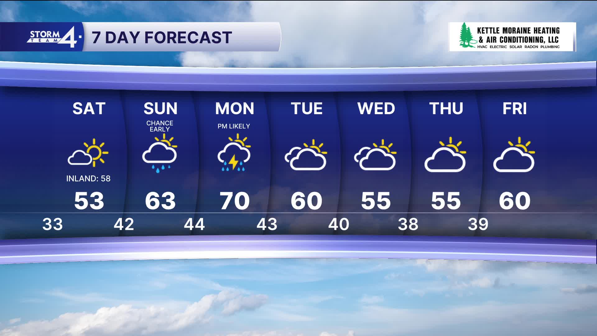
We will see some sunshine on Saturday. Highs climb into the low 50s with southerly winds around 10 mph.
Light rain showers are back on Sunday, but it will be warmer as temps are back to normal, reaching the 60s.
Watch out for some storms on Monday and stay with Storm Team 4 for the latest forecast updates.
TONIGHT: Partly Cloudy with Frost
Lows: 35 Lake 29 Inland
Wind: E 5 mph
SATURDAY: Mostly Sunny
High: 53 Lake 58 Inland
SUNDAY: Chance Showers; Mostly Cloudy
High: 63
MONDAY: Partly Cloudy; Chance PM Showers/Storms
High: 70
TUESDAY: Slight Chance Showers; Partly Sunny
High: 60
WEDNESDAY: Mostly Cloudy
High: 55
THURSDAY: Chance Showers
High: 55
It’s about time to watch on your time. Stream local news and weather 24/7 by searching for “TMJ4” on your device.
Available for download on Roku, Apple TV, Amazon Fire TV, and more.
